


Flood risk management plan for Leeds considered
6th January, 2019 - 23:47
Leeds City Council's executive board has given approval for an updated Local Flood Risk Management Strategy for the city. Work being carried out and planned to reduce the threat posed by flooding across Leeds will now go out for consultation.
As a lead local flood authority, Leeds City Council needs to have a Local Flood Risk Strategy which is refreshed every six years. The previous version of the strategy was developed in 2012 and adopted by the council in March 2014.
The purpose of the strategy is to guide the work being carried out on flood prevention by authorities and local agencies, which in Leeds is undertaken by Leeds City Council, the Environment Agency, Yorkshire Water, Highways England and Ainsty Internal Draining Board. It focuses on all potential sources of flooding and how they are being managed, as well as community engagement and awareness and emergency planning.
Lessons from Storm Eva
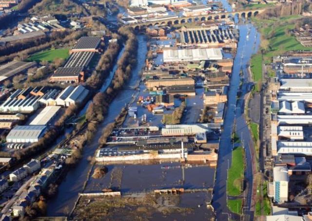
Over the last six years Leeds has suffered a number of flooding events, the most notable being the floods at Christmas 2015 caused by the impact of Storm Eva, which affected 3,355 properties with a direct cost to the city of an estimated £36.8million.
The lessons learnt following the Storm Eva floods have formed part of the update of the strategy, which also references a number of schemes in city completed since 2012 to protect communities across Leeds from a range of potential flooding causes.
The biggest of these projects is the Leeds Flood Alleviation Scheme, which saw the £50m phase one completed last year with measures in the city centre and Woodlesford including the use of state-of-the-art moveable weirs to control the flow of the River Aire.
The second phase of the scheme proposes a further £112.1m for works to protect the Kirkstall Corridor and communities along the River Aire up to its upper catchment. The planning application for this initial work was presented in December 2018, with further plans to follow once all the funding has been secured to offer a 1-in-200-year level of protection for Leeds against flooding from the River Aire.
Other projects
A variety of smaller projects have also taken place across the city, to improve water flows and reduce the threat of river flooding, surface water flooding and stillwater flooding. These include:
- £1.4m investment in increased flood protection for businesses at Stourton, including new 730-metre flood defence wall and property level protection such as floodgates and demountable barriers
- Westfields Flood Alleviation Scheme, Allerton Bywater – construction of bypass culvert and new watercourse to reduce flood risk to properties
- Glebelands Flood Alleviation Scheme, Garforth – Flood water storage area which significantly reduces risk to properties
- Barley Hill Recreation Ground, Garforth – Expansion of existing flood storage area which has proven to protect properties
- Ramsden Street Flood Alleviation Scheme, Kippax – Raised embankment which protects home from overland flooding
Other flood prevention schemes are currently in development for Otley, Mickletown and Lin Dike at Garforth and Kippax, together with a catchment assessment at Wortley Beck.
Consultation on the strategy which can be seen here (agenda item 9 and appendices) will now take place with stakeholders, before being debated at the full council meeting in March.
Flood storage area
Another major project approved by the executive board yesterday was to invest a further £3.15m in the Wyke Beck Valley project to provide enhanced flood risk management which aims to promote housing growth in east Leeds. The project includes the creation of a flood alleviation scheme at Killingbeck Fields, which would operate as a flood storage area and enhanced public greenspace. Complementary works are already underway at Arthur’s Rein and Halton Moor Local Nature Reserve.
The Wyke Beck programme is supported by funding from the Leeds City Region Enterprise Partnership (LEP), in partnership with the West Yorkshire Combined Authority, through the Leeds City Region Growth Deal and the Environment Agency, with £4.75m available in total. The main works will start in the coming months with the project scheduled to be completed by October 2019. To see the report and appendices go to https://bit.ly/2EceuIV (agenda item 10).
Working with communities
The council working with the Environment Agency and partners continues to develop its community engagement to raise flood awareness, with community flood groups set up in the city together with community activities and roadshow sessions, together with extreme weather and flood alerts to residents and businesses and guidance on emergency procedures.
Leeds City Council executive member for regeneration, transport and planning Councillor Richard Lewis said:
“As we come up on the three-year anniversary of the devastation caused by Storm Eva, the city knows all too well the threat caused by flooding which is increasing due to climate change and the frequency of extreme weather. Working with our partners and stakeholders we have done well to make considerable progress on measures to protect our city and communities, taking different approaches and a range of projects from very large scale to smaller works to manage and improve water flows.
“The Wyke Beck scheme reflects this strategy perfectly, with an imaginative approach to reducing flood risk also having massive potential to open up parts of east Leeds for regeneration to provide much-needed new housing, with residents and investors being given the confidence that flooding will not be an issue. It will also provide improved greenspace at Killingbeck Fields for families and people of all ages to enjoy spending time.”